Lake Ohrid sub-basin
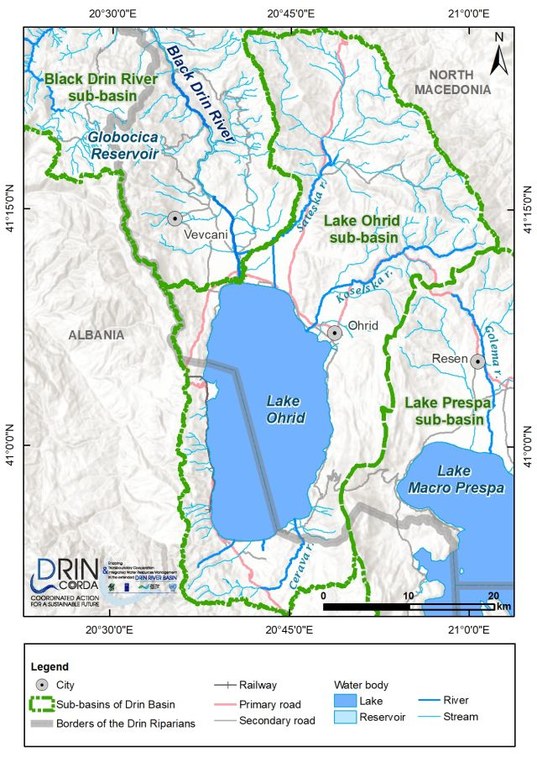
Lake Ohrid is called Ohridsko Ezero in North Macedonia and Liqeni i Ohrit in Albania. It is a tectonic lake with an average depth of 155 m and a maximum depth of 289 m. The average water residence time is 70-85 years.
Lake Ohrid is hydrogeologically connected to Lake Prespa, which sits around 150 m higher than Lake Ohrid (depending on water level variations). The hydraulic connection between Lake Prespa and Lake Ohrid, through the karstic massif, makes Lake Prespa its most important source of water, contributing over 40 percent of its water. It only takes six hours for the water to travel through the karstic system from Zavir/Zaveri to Tushemisht, which means that any change in the quality of Lake Prespa's waters would also affect - almost immediately - Lake Ohrid.

Water paths from Lake Prespa and rainwater falling on Mt. Galičica to Lake Ohrid Source: Popovska and Bonacci (2007)

WNW-ESE transect showing the underground karstic connection between Lakes Prespa and Ohrid, Source: Albrecht and Wilke (2008)
The Sateska River in North Macedonia is the lake's main surface tributary. In 1962, the river was diverted from its natural confluence with the Black Drin River into Lake Ohrid. The diversion almost doubled the size of the lake watershed and greatly increased its siltation (the mean annual sediment yield is over 100,000 m3). As a result, pollution levels of the lake, especially with respect to phosphorus, have significantly increased. There is ongoing work to redivert the Sateska River to its natural riverbed.
About two thirds of Lake Ohrid's water outflows pass into the Black Drin River (the only outflow of Lake Ohrid), while the remaining third either evaporates or is consumed. Since 1962, the outflow to the Black Drin River has been controlled with a weir that regulates the lake's water level. This limits water level fluctuation to within the range of about 1 m.