Drin Basin
Read the "Natural wealth & legacy of the Drin River Basin publication" in English here 
and in the languages of Albania and Kosovo here, Macedonia here, Montenegro here and Greece here
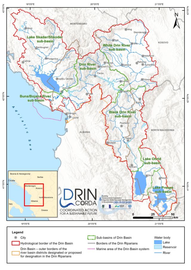
The Drin Basin sits in the south-east of the Balkan Peninsula with water bodies and watersheds spread across Albania, Greece, Kosovo1, Montenegro and North Macedonia. It comprises the sub-basins of the Black Drin, White Drin, Drin and Buna/Bojana rivers, of the Prespa, Ohrid and Skadar/Shkodër lakes, the underlying aquifers, and the adjacent coastal and marine area.
The total geographical area of the Drin Basin is 20,361 km2. The basin is characterized mainly by mountainous relief, the highest peaks of which are the Dinaric Alps at over 2,500 m above sea level, as well as flat land around the basin's coastal area in Albania.

Lake Prespa is the starting point of the water flow towards the Adriatic Sea, comprising two lakes (Micro and Macro Prespa) linked by a small channel, with regulated water flow, which traverses the alluvial isthmus that separates them. Micro Prespa is shared by Albania and Greece, while Macro Prespa is shared by Albania, Greece and North Macedonia.
Water also flows through underground karst cavities from Lake Prespa to Lake Ohrid. Shared by Albania and North Macedonia, Lake Ohrid is the largest lake in terms of water volume in South-East Europe. As the only surface outflow of Lake Ohrid, the Black Drin River flows north through North Macedonia. It forms the border with Albania for some kilometres, before entering the country between the cities of Debar and Peshkopi. The White Drin River rises in Kosovo and flows into Albania, where it meets the Black Drin River, near the city of Kukes, to form the Drin River.
Flowing westward through Albania, one branch of the Drin River joins the Buna/Bojana River approximately 1 km from where it flows from Lake Skadar/Shkodër near the city of Shkodra in Albania. Shared by Albania and Montenegro, Lake Skadar/Shkodër is the largest lake in terms of surface area in South-East Europe. The largest river flowing into the lake is the Morača River,which passes through Podgorica, the capital of Montenegro.
The Buna/Bojana River drains Lake Skadar/Shkodër and flows into the Adriatic Sea. Its lower part (23 km) forms part of the Albania-Montenegro border. The other branch of the Drin River, which is the older branch, discharges its limited flow directly into the Adriatic Sea, south of the city of Shkodra, near the city of Lezhe.
A number of aquifers exist, often with complex groundwater-surface water interaction and interdependency. There are five large reservoirs used for hydropower production and more than 110 irrigation reservoirs.
With its extensive water resources (the third greatest river discharge into the European Mediterranean, after the Po and Rhone rivers), this complex system provides a wealth of services to the Drin Riparians that share the basin: energy supply, recreation and tourism, fisheries, water supply for irrigation and domestic uses, sustenance of unique endemic biodiversity, and livelihoods. The basin is home to over 1.61 million people, living in over 1,450 settlements.
------------------------------------------------------------------------------------------------------------------------------------------------------
[1] This designation is without prejudice to positions on status, and is in line with UNSCR 1244/1999 and the ICJ Opinion on the Kosovo declaration of independence.
[2] The river is called Drin i Zi in Albania and Crn Drim in Noth Macedonia.
[3] The river is called Drini i Bardhë in Albania and Kosovo.
[4] The river is called Buna in Albania and Bojana in Montenegro.
[5] The lake is called Skadar in Montenegro and Shkodër in Albania.
[6] A landscape formed by the dissolution of soluble rocks, including limestone and dolomite.